
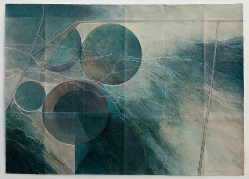
Jean Davey Winter
Mapping the Land – Nevada 1
mixed media
39 x 55 in.
In my current practice I work with photography, digital manipulation and painting to explore concepts relating to travel, the journey and mapping. Somewhere between landscape and map the starting point for this work comes from photographs taken on flights, also found images from internet mapping sites. The higher the viewpoint the more abstract and map-like the image. Aerial perspective provides an increased awareness of the delicate balance between man and the environment giving an overview of the marks made upon the earth’s surface by activities such as transport, urbanization, mining and agriculture. Using the folding map format, acrylic paint is combined with printed, digitally manipulated images on un-stretched calico. Use of the internet enables me to trace journeys made by road, or rail, or to explore more remote locations from my computer in the UK; extending and redefining the definition of travel and taking it into another dimension. In a world where the folding paper map is fast becoming obsolete in preference to the use of satellite navigational devices such as GPS in our cars and cell phones this work references the map making traditions of the past whilst linking them with the technology of today.